
FRV Loop Revisited October 2022
- Mat Jobin
- Jan 14, 2023
- 13 min read
Updated: Apr 11, 2024
Total Miles: 40 miles
Total Elevation: 5,367 ft
Duration: 2 Days
The FRV Loop is a unique backpacking loop located in the Farmington River Valley of central Connecticut. The loop (formerly known as the LKD Loop) circumnavigates the valley by way of the West Mountains and Metacomet Ridge.

It had been a while since I hiked this loop I created back in 2018 and it's been just about as long since I've written a blog post. So what better way to get back into the writing than with a re-visit of this special backpacking loop. It's been building a lot of momentum lately from others wanting to explore it, so my hope is that this updated trip report helps those interested in tackling it.
The FRV (Farmington River Valley) Loop is a backpacking loop I created back in 2018 in celebration of National Trails Day/CT Trails Weekend. It is made up of a network trails and several properties around the Farmington River Valley in northern central Connecticut. Those properties and trails are:
West Ledge, Tanager Hill, and Tulmeadow Farm (Simsbury Land Trust)
New England Trail (1 of 11 National Scenic Trails in U.S.)
McLean Game Refuge (National Historic Landmark)
Stratton Brook State Park & Penwood State Park (Connecticut State Parks)
Farmington Canal Heritage Trail (Southern New England Multi-Use Rail Trail)
Farmington River Trail (Southern New England Multi-Use Rail Trail)
Simsbury Historic District & Town Of Granby
A video of my solo backpacking trip on the loop in October 2022. I went counter-clockwise for this one.
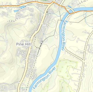
FRV Loop Maps
What To Expect On The FRV Loop?
Terrain: rocky, rooty, singletrack, scree, forest service and farm roads, asphalt, soft and hard pack dirt
Vegetation: hardwood forest, wetlands, farmland
Wildlife/Insects: black bear, coyote, bobcat, chipmunks, squirrels, fox, hawks, owls, copperheads, ticks, bees, flies, mosquitoes
Remoteness: not too remote, cell service might be spotty in places but otherwise reliable
Water/Resupply: water is pretty reliable along the western half of the loop in most places depending on seasonal conditions it can get trickier along the Metacomet Ridge and New England Trail on the eastern half of the loop, resupply isn't required for such a short loop but there are some options just outside of the loop in the towns of Granby, Tariffville and Simsbury
Possible Natural Hazards: flooded trail, blowdowns, thunderstorms, snow storms, heat/humidity, wind, lightning
Permits: not required for this loop, though camping is limited to one designated campsite on the NET and is first come first serve
Season: this engaging loop can be hiked year-round and offers something different in each season
Trip Planning & Logistics

A satellite view of the FRV Loop
West Ledge

There are several starting point options for this loop, but the best and most reliable is at The Master's School. This will break the loop into half, making each day a 20 mile day. I've always contacted The Master's School in advance to ask if I can park on their property and they've always been accommodating. This makes the pre-trip preparations easier and offers a nice starting point for the loop. Though this loop can be completed in all seasons, try to avoid going during the winter if any significant snow is expected or your car will most likely be plowed in. The same will apply to all of the other starting point options throughout the loop. This loop is also unique in that you might also be able to get by without needing a car at all. Part of the FRV Loop goes by a CT Transit route, so depending on your location there might be an option to take the bus to a different point along the loop. This would then shorten or lengthen the mileage for each day depending on your starting point.
Day 1: 20 Miles
Starting from the lot, I like to take a red blazed trail that leads to West Mountain. Some spots can be waterlogged depending on the time of year, but it is a fun moderate climb to the peak. The top offers a view of the eastern half of the loop, and a view of Mt Tom and the Seven Sisters that are part of the New England Trail in central Massachusetts. From the overlook, I'll then head north with a steep and very rocky descent to Cathles Bridge. This is the first of several water fill-up options for the day. Next, I'll continue briefly on a white blazed trail and then a blue blazed trail which heads south toward Simsbury Reservoir. This trail then skirts the outer perimeter of the school buildings before coming to a junction with the red blazed trail south of where I start. Here, I like to continue south until I reach a bridge crossing that passes over Hop Brook. A yellow blazed trail will then lead to a dirt parking lot for West Ledge and an exit of the land trust. This begins the first of two road walks required to allow for a cohesive loop. Most of this road walk is on a quiet residential road with a good climb.

McLean Game Refuge
Eventually there will be a bend in the road and some off shoulder parking by a trail. This is one of several entrances into the 4,400+ acre McLean Game Refuge. This is one of my favorite sections of the loop. It holds several highlights including the possibility of seeing a black bear. There are several water fill-up options throughout this stretch and cell service can be spotty, but there is a likelihood of passing other hikers.

One of the highlights along this section of the loop is East Barndoor Hill. The climb to the peak of this prominent knob involves some fun traprock scrambling and weaving through a fragile ecosystem along a pathway put in place by the Refuge. A large cairn will mark the highest point of the peak. Descending the summit, I'll connect to a network of old dirt service roads and follow them out to a main parking lot for the refuge and exit of the property.

Farmington Canal Heritage Trail
The FRV Loop then passes through a short stretch in the town of Granby that includes a local grocery store, Dunkin' and a restaurant called Tiger Belly which serves some delicious food. So there are some options if I'm ever craving something or want to pick something up for the rest of the loop. It then picks right back up on part of the Farmington Canal Heritage Trail. The FCHT is a paved multi-use rail trail that spans from New Haven, CT all the way north to the MA/CT state lines, and also ties in with the longer 3,000 mile East Coast Greenway. The short section utilized by the FRV Loop is fairly quiet and secluded which provides a pleasant walk through a green tunnel (or not so green tunnel if hiking in stick season).

After a couple of miles along the FCHT, the FRV Loop branches off onto Turkey Hill Rd (Rte 20). This section can be very busy with traffic depending on the time of day, but it is the only way to keep things as a loop. There is a fairly wide shoulder in some spots and opportunities to get off the road completely if desired. The FRV Loop then connects to the New England Trail at a 4-way intersection with a traffic light. Once on the NET, it is about a 2 mile hike to camp.
New England Trail & Camping
Water can be tricky here and along the entire Metacomet Ridge, but it sure has some beautiful views. If I'm running low, I'll usually hike about 0.9 mile below the ridge and summit of Peak Mountain to get water from a stream near a recreation area. I'll then hike back up to the ridge and continue toward camp. There is also an option to hike 0.8 miles into town to a gas station by continuing on Rte 20 instead of getting onto the NET, then retracing steps back to get onto the trail again. I've always found the stream to be pretty reliable. If you're looking to tackle a shorter thru-hike, the entire New England Trail is a great option. It is one of eleven National Scenic Trails in the United States. At 230 miles, hikers travel from the Atlantic Ocean shores of Long Island Sound to the borders of Massachusetts and New Hampshire. The trail can then continue to be hiked as the Metacomet-Monadnock Trail and the Monadnock Sunapee Greenway, followed by the SRKG. It can then be linked to the White Mountains in New Hampshire with some road walking. In the White Mountains you then have the option to link up with the Cohos Trail for a grand finish in Quebec. I've thru-hiked all of these trails, but individually and not all together as one. I would love to hike them all together sometime in the future. Not to drift too far from this blog post, the New England Trail itself can take anywhere from 2-3 weeks on average. My first NET thru took 14 days and the second thru took 9 days. I have hopes to complete another thru hike of the trail in the near future, but for now I'm always out on favorite sections including what is part of the FRV Loop.

The FRV Loop utilizes the Windsor Locks Primitive Campsite, one of several designated campsites on the NET and the only place to camp on the entire loop. It is first come, first serve and has plenty of flat ground for a few tents or tarp setups. There are also a few good sized trees for hammocking. The site is pretty barebones which is one of the things I love about it. There is no lean-to shelter and no privy. Campfires are not allowed for several reasons including its proximity to a residential area. That's never been trouble for me since I prefer to hike all day and spend little time at camp, only to rest and recover for the following day. The site has plenty of options for a proper PCT bear bag hang or Ursack hang too. There is also an insulated box with a stored water cache that is maintained by Connecticut Forest & Park Association and at times a local Boy Scout Troop. I've found this to be pretty reliable, but it is dependent on hikers to report when water is low which is why I might take a detour before arriving at camp to fill-up depending on how I'm feeling. If you're there and water is low, contact CFPA to let them know for any future hikers passing through. They are a fantastic organization that manages a very large portion of the NET and over 850 miles of hiking trails across Connecticut.

Day 2: 20 Miles
The following morning, I'll make some coffee, pack up and have my breakfast on-the-go while I hike the 2 miles back to the 4-way intersection and continue south on the NET. This stretch has several flowy ups and downs along traprock with some ridge walking, beautiful views, a unique cemetery restoration project and T-ville Gorge which has been home to several whitewater kayaking competitions in the past. There are also remnants of an old resort (Bartlett Tower which was later renamed Manahoose Lodge, most was destroyed in a fire in the 1930s) and Lake Louise which is a glacially created lake and one of the highest in elevation in CT. After walking around this lake, I'll leave the NET and connect to a yellow blazed trail in Penwood State Park for a short stretch before connecting to a blue blazed trail that descends steeply into a Simsbury Land Trust property known as Tanager Hill.

Simsbury Center, Land Trusts & Parks
Tanager Hill is one of several Simsbury Land Trust properties and is the next that this loop passes through when completing it clockwise. The hiking through this parcel of land includes wide open meadows and gentle rolling terrain. The meadows have always been well maintained when I've gone through as they are part of a small network of trails there. There are also a couple of water fill-up options here, but they aren't always reliable.

From the exit of Tanager Hill, I'll then continue with a short road walk to a junction and make my way southwest for another short road walk along the Farmington River before coming to the Old Drake Hill Flower Bridge (currently closed - see trail notice at the end of this post). Depending on the time of year, this historic bridge can be very busy and rightfully so. I've seen holiday lights and decorations around the bridge, planters and flowers, yoga classes, wedding photographers and a unique art sculpture display at the bridge back in 2018 that was part of the Simsbury Art Trail.

The bridge is also the northern terminus for the Farmington River Trail which quickly passes through the Farmington Canal Heritage Trail. These two multi-use rail trails also create one of the only rail trail loops in the northeast. Before reaching the junction of the two trails, there are several options for food, water and supplies in the historic center of Simsbury. At the junction of the two rail trails, the backpacking loop continues along the Farmington River Trail with a paved section that is off the road from traffic before it enters Stratton Brook State Park. This stretch continues to be flat, but the ground turns to soil and then finely crushed gravel before turning back into pavement with an exit at the opposite end of the park. I'll then follow a road straight ahead which leads to another Simsbury Land Trust property and partnership with a local farm known as Tulmeadow. The hiking trails and land here always reminds me of Vermont. Dense forested land eventually gives way to open meadows, farm fields and a view of the West Mountains. The loop then passes by the Tulmeadow Farm Store filled with treats, gifts and fresh ice cream. The ice cream makes for a great reward as the loop nears a close with about 1.5 miles left to finish. After leaving Tulmeadow, I'll take a short road walk one last time and enter West Ledge by with a left at the entrance to The Masters School. A brief walk along an unmarked old forest road will then connect to the red blazed trail which I will then follow back to where I started.

Gear I Used On My Recent Solo Trip
I went out for this trip with a 5.5lb/2.49kg baseweight and was really happy with how everything performed, not to mention the benefits that come with carrying a light pack. Though I'm always testing new gear I've purchased out of personal interest and to provide honest feedback to my clients and readers/viewers, I'm pretty dialed with what I typically like to use and I wouldn't change anything I had used to complete this loop at the beginning of October.

I carried everything in what has become one of my favorite packs I've used and owned over the years, my 24 liter Pa'lante Joey. This running vest style pack has everything I need yet remains simple and is very comfortable. Since my pack is made of Robic nylon, I always line the inside with a Nylofume liner to protect my Enlightened Equipment Enigma 30 degree quilt and things I want to keep dry. My shelter preference most of the time is a flat tarp, so I went with my Zpacks 7x9 DCF tarp. I love the openness that a tarp offers along with its simplicity and versatility. If there is going to be significant bug pressure or some rain expected, I'll pair my tarp with a Borah Gear DCF bivy. The conditions did not warrant bringing it for this trip so I left it at home and brought a mosquito headset for the bugs, but that ended up staying in my pack. My sleep system consisted of my Enigma quilt, a Gossamer Gear Thinlight 1/8" CCF pad and a Sea To Summit Aeros Down pillow. This worked beautifully on the soft packed ground and allowed me a good night's rest. I used a piece of Tyvek as my ground cloth to provide a clean surface to go through my gear and to sleep on.

My shelter and sleep system. I hike with one trekking pole for water crossings so the opposite end of my tarp is supported with a stick I found on the ground at camp.
Footwear is always going to be subjective and one of the most personal choices we make. After all, what works for me might not work for someone else. I wore my Altra Lone Peak 6 on this loop and they handled the terrain really well. The Lone Peak has been my-go to over the years, and the 6 is one of my favorite iterations of the shoe. I'm currently over 700 miles with a pair! In conjunction with my footwear, I wore a thin pair of Injinji toe socks. This combination is what I've found to work best for me. For the rest of my clothing, I wore Patagonia Nine Trails running shorts with a built-in liner, a polyester short sleeve button up shirt, my Senchi Designs Wren Polartec Alpha Direct fleece and a lightweight trail running cap. I had packed my Patagonia Houdini wind shell and Montbell Tachyon wind pants but never needed them. The fleece has been a game changer for me and was highly versatile while completing the loop. It was my active insulation for the cool morning starts before the sunrise and it was also part of my sleep system at night.
I went stoveless for this trip and had cold pizza I packed out from town when I passed through. The rest of my food bag was filled with a nut mix, kale chips, nori, dehydrated fruit, fig bars, nut butters, a couple of other bars, a multi-vitamin, instant coffee and some electrolyte replenishment powders. My water treatment for this trip was Aqua Mira, which has been one of my favorite treatment methods over the years. Aside from that, the rest were a few odds and ends. For those interested in my complete gear list it can be viewed here:
And if you'd like to get an idea of how I pack my 24 liter pack for a backpacking trip, you can view that here:
Completing the FRV Loop in the fall was a real treat and it felt great to be back out on this unique loop. Temps were in the mid 70s during the day and the low 50s at night, which provided for comfortable hiking without many bugs. The foliage was beginning to really show and it brought a new perspective to a familiar place. I have now also completed this loop in all four seasons and it's been a lot of fun to see the changes that each one brings. Along with the foliage and highlights along the loop, I also had two owl sightings. One adult barred owl directly over the trail on my way to camp and another younger barred owl close to camp. Water was reliable in most places, but was running a little low at camp.
A look at a past solo trip I took on the loop in winter 2018-2019.
FRV Loop Maps
(Maps can be used in conjunction with loop details in this post. Starting in top column, from left to right, this will bring you clockwise around the loop)


*Trail Notice 10/15/2023: The Old Drake Hill Flower Bridge is currently closed to foot traffic through Fall 2024 due to renovation updates to preserve this historic landmark. A bypass of this section is available by walking Drake Hill Rd over the Farmington River and connecting to the Farmington River Trail.

Thank you to CFPA, McLean Game Refuge, Simsbury Land Trust, Farmington Valley Trails Council, The Masters School, CT DEEP, New England Trail, trail maintenance crews and everyone who has made this loop possible. If you have any questions about the FRV Loop or any of my gear, feel free to leave a comment in this blog post or you can send me a message by clicking on the Contact tab in the main menu on the website. I would be happy to help you get out there and hike this fun backpacking loop. It has a little bit of everything. If you've completed this loop, I'd love to hear what your experience was on it. Private guided trips with Reach Your Summit on this backpacking loop are also always available upon request. Thank you for reading. I hope this has been helpful in someway, if not just entertaining.
Mat 'Knowledge' Jobin


Comments